
Landscape
Beltana is located on the western edge of the northern Flinders Ranges of South Australia, 240m above sea level. It is nestled among low rocky hills and along the bank of the Warrioota Creek. From the town can be seen the main peaks of Mt Stuart (881m high and 20km away to the east), Mt Bayley (510m high and 7.5km to the north) and Mt Deception (610m high and 19km to the west). The township is surrounded by surveyed parklands and suburban blocks, and these in turn are surrounded by a town common which provides a buffer between the town and the pastoral leases of Beltana, Puttapa and Moorillah stations. Beltana is approximately 230km north of Pt Augusta and 530km north of Adelaide. The town of Leigh Creek is 40km to the north, and the township of Parachilna is about 45km to the south. Beltana is 12km along a sealed road from the main highway.
Watercourses
Just west of the town, Sliding Rock Creek joins Warrioota Creek; both creeks begin in the mountainous area to the east and flow westwards towards Lake Torrens. The town itself is bisected by 3 small creeks that flow into Warrioota – one that follows the old roadway to Sliding Rock between the school and the ruined bakery; Graham's Creek that flows through the northern parklands behind the Hall and Telegraph station and the third that flows roughly parallel with the old railway line behind the freight shed. A series of low, water control weirs originally funneled these smaller creeks into the railway dam; sadly much of this small scale civil engineering work is now in disrepair or lost.
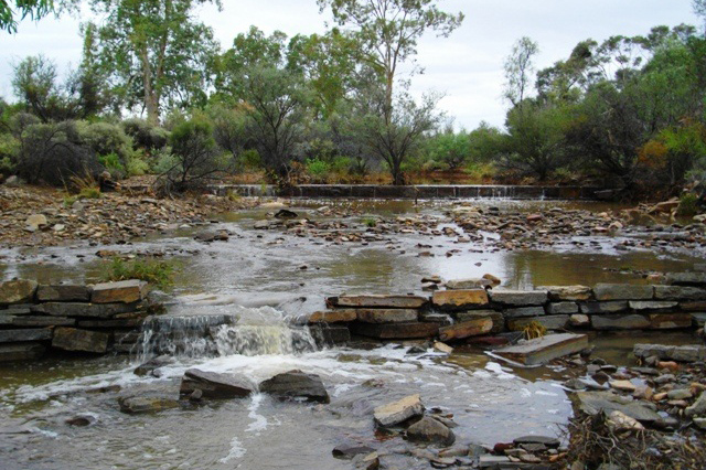
Due to the town's proximity to the creeks and the area's unpredictable weather, heavy rainfall has often led to flooding. Beltana has experienced six months with no rain (1960–1961) and six months with over 300mm of rain (1975–1976) and drought has caused the area to be unstocked for long periods (1903–1909). Rainfall has ranged from 57mm in 1902 to a record 408.6mm in 1974 with a long term average of 205mm. There are occasional winter frosts, hailstorms and one recorded snowfall (on Mount Hack and Mount Stuart in July 1971). Duststorms are not uncommon, although modern stocking practices of surrounding pastoral properties have reduced their severity and frequency.
Birds and animals
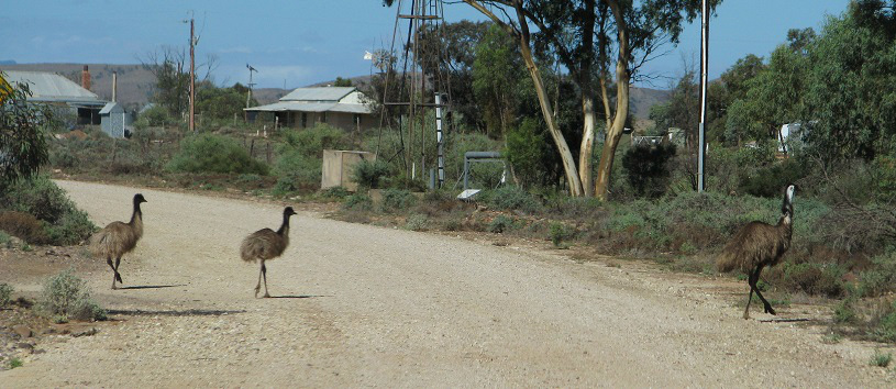
The Beltana Spring in Warrioota Creek, is today silted up and due to dry conditions is not currently active although in wetter years it has been known to run for more than 12 months at a time even with the higher level of the creek bed. The water, the large river red gums and stands of paperbarks provide an ideal habitat for a variety of birds and other native animals. Emus are commonly seen, as are galahs and little corellas. Crested pigeons, mallee ringnecks, crows and magpies, flocks of green budgerigars, zebra finches, welcome swallows, variegated wrens and several different species of honeyeaters are also found, especially after a good season. Kangaroos, wallabies and euros can be seen around the town as well as goannas, sleepy lizards, bearded dragon lizards, geckoes and snakes.
Trees, bushes and flowers
Away from the gum-lined Warrioota, the most common plant is the Acacia Victoriae, or Prickly Wattle – straggly and dull for most of the year, but stunningly covered in pale yellow blossom for a few weeks in spring. Saltbush and bluebush are also common and samphire grows on salt affected dry ground. Following good winter rains, the local eremophilas – freelingii and duttonii – flower profusely on the rocky hills and occasionally Sturt desert peas cover large areas and desert roses bloom along the creeks. Beltana also has several quandong, or "wild peach" trees along the smaller creeks and they fruit in spring. Not far from the town can be found stands of red mallee, black oaks and melaleucas. From time to time, stock grazing on the town common put pressure on these plants and cause erosion of the fragile soil.

